


 Reply With Quote
Over to you Graeme.")

 Master
Subscriber
Master
SubscriberYes the bridge at the bottom of Bowens Creek Road and yes that road is well travelled. But the road changes name at the creek. My car is pointing towards Bowens Creek Road. I had just come down Mt Irvine Road from Bilpin. Now that road is definitely not well travelled.
I will let Roger and Graeme decide who goes next.
Cheers
Mike
AT REST
SubscriberOver to you Graeme.
Roger
 Swaggie
Thanks but squarely beaten to the post. I started to post some time earlier but decided that it wasn't the road so perhaps next time I'll not be so hesitant to try.
I'm surprised that the road still isn't sealed as it would have been over 30 years since I was last on it.
MY21.5 L405 D350 Vogue SE with 19s. Produce LLAMS for LR/RR, Jeep GC/Dodge Ram
VK2HFG and APRS W1 digi, RTK base station using LoRa
AT REST
SubscriberLast time I was out that way there was and old 'Road Closed' barrier at the Mt Irvine end but with plenty of evidence of people (locals etc probably) having ignored the signage and driven around it.Originally Posted by Graeme

Anyway to keep the comp rolling lets move to a warmer climate for this location, taken just a few days ago.
Roger
Master
SubscriberThere is a road closed sign at the beginning, but the barrier about 2km further in was open last time (a couple of years ago). The photo was taken about 18 months before that, again barrier open. Track is not bad, narrow, badly eroded by run off in places.
The bridge, however was deteriorating last time I was there.
I heard that the Mt Irvine locals were agitating for repairs so that it could be used as an alternative escape route in case of fires.
Cheers
Mike
Last edited by rocmic; 10th July 2016 at 12:46 PM. Reason: Dyslexic fingers
Master
SubscriberJust a guess, Airlie Beach
AT REST
SubscriberIMHO, an important and very valid reason which also applies to numerous National Park areas where alternate ingress/egress routes have been closed.
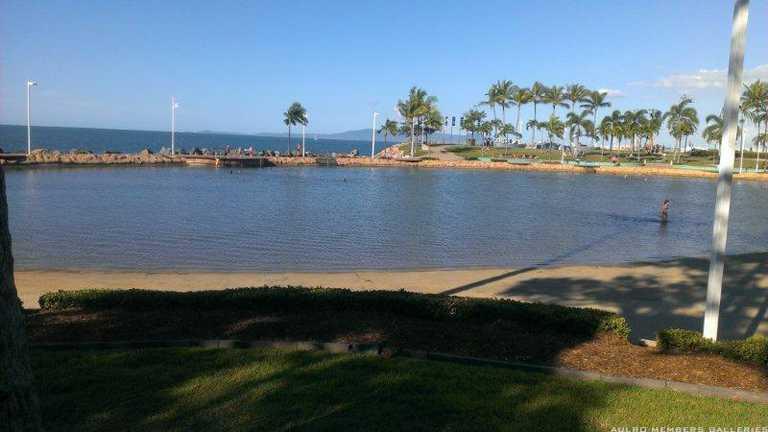
Further north than Airlie and the specific area is referred to by the name of the pool in the foreground.
Roger
Wizard
SubscriberRock Pool, Strand, Townsville.
[SIGPIC]
2012 LR Defender 90 (BERT) Gone
2012 Husqvarna WR 300
2014 FPV F6 Gone
2005 D3 SE V8
2011 D4 V8
2016 Moto Guzzi California Audace.
AT REST
SubscriberSpot on
Where to now carlschmid2002?
Roger
AT REST
Blue Mountains residents call for government action over road access in bushfire zone - ABC News (Australian Broadcasting Corporation)
Looks a little worse for wear in this pic.
Martyn
1998 Defender
2008 Madigan
2010 Cape York
2012 Beadell, Bombs and other Blasts
2014 Centreing the Simpson
VKS-737 mob 7669
 Posting Permissions
| Search AULRO.com ONLY! |
Search All the Web! |
|---|
|
|
|

Bookmarks