-
26th January 2005, 02:10 PM
#1
OziExplorer users (particularly in NSW)
For those that use OziExplorer a download from this site
http://sourceforge.net/projects/maprequest/
will enable you to download maps and create the .map file from the NSW LPI site.
<span style="color:blue">Example from the Snowball Sheet (Bendethra)</span>
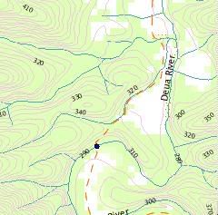
The maps don't have any grid so are really only applicable in a mapping program
Its a bit fiddly (esp if not very computer literate) and requires you to have java installed on your computer (available here)
http://java.sun.com/j2se/1.4.2/download.html
with a bit of fiddling you can get very acceptable resolution maps of any part of NSW with the latest data.
For our Qld counterparts there is a link to some qld mapping but I've had a look at it and quite frankly its crap (I looked at the area around Caboolture).
Bushie
-
26th January 2005, 02:47 PM
#2
G'day Bushie,
I've tried to access the NSW LPI site with maps:
http://maps.nsw.gov.au/
No luck. Appears that there has been some bureaucratic shuffling
Do you a have current link?
-
26th January 2005, 04:17 PM
#3
-
26th January 2005, 05:34 PM
#4
Originally posted by one_iota
G'day Bushie,
I've tried to access the NSW LPI site with maps:
http://maps.nsw.gov.au/
No luck. Appears that there has been some bureaucratic shuffling
Do you a have current link?
Mahn,
That link still works OK for me - It takes you to a disclaimer page first.
http://maps.nsw.gov.au/viewer.htm should take you straight in.
The maprequest app allows you to download multiple windows from the server and assembels them as a single page (or something like that) the end result is you end up with a map you can use in Ozi.
Bushie
 Posting Permissions
- You may not post new threads
- You may not post replies
- You may not post attachments
- You may not edit your posts
-
Forum Rules
Search AULRO.com ONLY!
|
Search All the Web!
|


 Reply With Quote
 AT REST
Bookmarks