Page 2 of 3 FirstFirst 123 LastLast
Results 11 to 20 of 22

Thread: Ozi explorer off road mapping for GPS

  1. #11
    Join Date
    Feb 2011
    Location
    Brunswick, Victoria
    Posts
    3,778
    Total Downloaded
    0
    Quote Originally Posted by isuzutoo-eh View Post
    They are proper topo maps same as you'd buy from the map shop.
    Perhaps that is the case for NSW, but the Festy Vic mapping is pretty average, and is getting on for 7 years old.

    I picked a random section of Victoria - well not entirely random I had trouble getting through this area during floods a couple of years ago - and cropped the mapping to cover a similar section just to demonstrate how different the coverage really is.

    First up Festy.org mapping (Ozi) - Free


    VicMap Topo 25K (Memory-Map) - $99 for 2 x mobile device, $150 2 mobile + 2 desktop, $199 for DVD.


    SpatialVision VicMapBook imagery 50K/100K (Ozi) $149.00 DVD Only.


    GA AusTopo 250K (Ozi and Memory-Map) Free//Cheap


    Hema Victorian State Map (Ozi and Memory-Map) On DVD for Ozi $179, or Part of Region 1 download for Memory Map - $60 for 2 x mobile and 2 x pc.


    One of the hallmarks of usable GPS mapping is the ability to see the information you need at a zoom level that gives you reasonable coverage.

    cheers
    Paul

  2. #12
    Join Date
    Feb 2011
    Location
    Brunswick, Victoria
    Posts
    3,778
    Total Downloaded
    0
    A second example of what you get for your money.

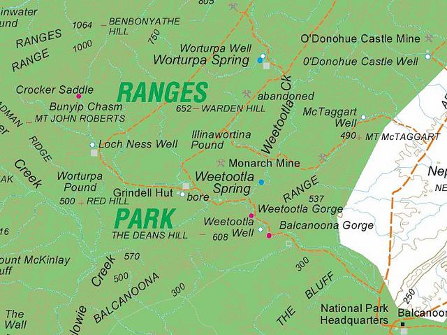
    This is a section of the Gammon Ranges NP in SA.

    AusTopo 250K - Free/Cheap


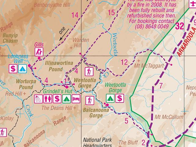
    Hema Flinders Ranges map (Region 4 - Great Desert Tracks ) $60


    Note the Track between Balcanoona Gorge to Grindell's Hut. There is no indication on the AusTopo 250K that this is a walking track only.

    FWIW the pic in my sig is taken on the track into Grindell's Hut.

    cheers
    Paul

  3. #13
    Join Date
    Apr 2008
    Location
    Near Seven Hills, Sydney
    Posts
    4,342
    Total Downloaded
    0
    Thanks for the map comparo. I haven't used the Vic maps yet but the NSW 1:25k maps work well in my opinion.

  4. #14
    Join Date
    May 2006
    Location
    Yack
    Posts
    1,388
    Total Downloaded
    2.78 MB
    Thanks OFFTRACK
    I know what type of driving I will be doing...Vic Alps, Upper Murray high country, northern and central Australian touring ie Gulf/Cape, Simpson etc. Why do you think a tablet would be best for me?

    cheers

    Lindsay

  5. #15
    Join Date
    Apr 2008
    Location
    Near Seven Hills, Sydney
    Posts
    4,342
    Total Downloaded
    0
    I found with a smart phone the screen was too small to show enough map in enough detail, my 4.7" GPS, although bigger than the phone, wasn't much better. Now the 10" tablet has scads of room for detail and forward planning. It doubles as a lot of other things too as a tablet PC should...

  6. #16
    Join Date
    Feb 2011
    Location
    Brunswick, Victoria
    Posts
    3,778
    Total Downloaded
    0
    Quote Originally Posted by Linds View Post
    Thanks OFFTRACK
    I know what type of driving I will be doing...Vic Alps, Upper Murray high country, northern and central Australian touring ie Gulf/Cape, Simpson etc. Why do you think a tablet would be best for me?

    cheers

    Lindsay
    I just think you'll find it easier to keep mapping and apps up to date. Most of the Chinese GPS units don't come with legal copies of the turn by turn GPS apps like iGo so you need to spend time chasing up dates on forums and the like. It's a PITA when all you really want to do is a simple update.

    The Ui will also be miles better than anything that runs on WinCE.

    The other advantage is you get your internet connectivity and e-reader capability. It's an all round better deal.

    I'd avoid a 10" tablet if you want to windscreen mount - they are just too big!

    The Hema maps would be pretty good for what you want to do.

    Cheers
    Paul

  7. #17
    Join Date
    May 2006
    Location
    Yack
    Posts
    1,388
    Total Downloaded
    2.78 MB
    Quote Originally Posted by OffTrack View Post
    I just think you'll find it easier to keep mapping and apps up to date. Most of the Chinese GPS units don't come with legal copies of the turn by turn GPS apps like iGo so you need to spend time chasing up dates on forums and the like. It's a PITA when all you really want to do is a simple update.

    The Ui will also be miles better than anything that runs on WinCE.

    The other advantage is you get your internet connectivity and e-reader capability. It's an all round better deal.

    I'd avoid a 10" tablet if you want to windscreen mount - they are just too big!

    The Hema maps would be pretty good for what you want to do.

    Cheers
    Paul
    Thanks for your advice OffTrack much appreciated. So if I were to look for a tablet where would I start? Firstly I need
    ***a good windscreen mounting system
    ***7 or 8 inch screen
    ***car charger

    What OS is preferable?
    What processor speed is acceptable for this application?
    Android or other?

    I will have look about and post anything of interest in here - I know Im not the only one on this path.

    Thx for all the input/advice so far.

    L

  8. #18
    Join Date
    Jan 1970
    Location
    Melbourne
    Posts
    1,545
    Total Downloaded
    0
    Quote Originally Posted by Linds View Post
    So if I were to look for a tablet where would I start?
    Hard to go past the Nexus 7. A lot of bang for the buck.

  9. #19
    Join Date
    Feb 2011
    Location
    Brunswick, Victoria
    Posts
    3,778
    Total Downloaded
    0
    Worth taking a look at Robert Peppers coverage of Android tablets.

    Tablet offroad navigation - Android Honeycomb, Oziexplorer and more | 4WD Book & 4X4 News
    Android Tablets for offroading - what's on the market? | 4WD Book & 4X4 News

    I'm a professional Mac geek so can't really comment on which specs are necessary on Android.

    If you wanted to go for an iPad the Mini wifi/cellular would really be the only choice. All the iPad versions of the gps apps will happily run on a Gen 1 iPad so will be fine on any of the more recent devices.

    I think for you planned travels either Memory-Map or Ozi would be fine, although if you went with an iPad Ozi is no longer an option.


    I'd started doing this chart the other day but got way-laid trying to convert the Spatial Vision maps to MemoryMap format. It's not complete and by no means exhaustive.

    cheers
    Paul
    Attached Images Attached Images

  10. #20
    Join Date
    May 2002
    Location
    Heathcote (in "The Shire")
    Posts
    5,348
    Total Downloaded
    0
    Quote Originally Posted by OffTrack View Post


    cheers
    Paul
    What is the chart meant to show ?
    Are you saying NSW Topo are not able to be used in Ozi ?
    Which would be incorrect, hence I'm unsure of how I am meant to be interpreting the chart.


    Martyn

Page 2 of 3 FirstFirst 123 LastLast

Bookmarks

Bookmarks

Posting Permissions

  • You may not post new threads
  • You may not post replies
  • You may not post attachments
  • You may not edit your posts
  •  
Search AULRO.com ONLY!
Search All the Web!