


 Reply With Quote
That gorge looks magic. How far down from the main gorge is it?Originally Posted by cjc_td5


 ChatterBox
Subscriber
ChatterBox
SubscriberI will pay that in the absence of a more precise answer! Bachsten Falls, on Bachsten Creek, about an hour's walk from the Bachsten Camp on the Munja Track. Easily as spectacular as Mitchell Falls, with about a one-squillionth of the number of people and no fleet of helicopters overhead from dawn til dusk. Made me wonder how many other spectacular sights are hidden away up there.
Over to you Xtreme.
ChatterBox
SubscriberThat gorge looks magic. How far down from the main gorge is it?
 ChatterBox
The main falls are just out of sight upstream. The far hill on the horizon is immediately above the top pool of the falls and is the backdrop to many a photo of the main falls.
The vast majority of visitors swim in the pool below the main falls and don't think to float downstream for 200m for another spectacular vista.
Last time we were there 2 years ago the water painfully cold though and swimming was not fun.
Cheers Chris
AT REST
SubscriberYour clues of distance and bearing made it a no brainer.
Did you access it with Bushtrack Safaris or were you able to do it alone and did you go right down to Walcott Inlet?
Although I've been to the Kimberley area twice already, Bachsten Falls will definately be included on my next visit.
Let's move south east for the next one -
Roger
ChatterBox
SubscriberWe did it solo- don't tell me they've sold out to a tour company as well!! Gotta wonder what the hell is left for the independent spirit. We got to Walcott Inlet- I posted a photo earlier in this thread- although the track had not been prepared past Bachsten that year and the last 2 days drive were through 6ft tall grass. It was the highlight of our last Kimberley trip as well as the focus of our trip prep.
Glad you've tsaken us south-east as this thread has spent way too much time in QLD for my taste! No idea though.
AT REST
SubscriberTime for a clue or two -
1 - The background in the photo was changed rapidly in 2009, a mere five years after the photo was taken.
2 - The item in the lower right of the picture would have been in much demand during the rapid change/s.
Roger
ForumSage
SubscriberI assume that you refer t Black Sunday?
But I can't work out where that was taken, so much was devastated from King lake right through...
(REMLR 235/MVCA 9) 80" -'49.(RUST), -'50 & '52. (53-parts) 88" -57 s1, -'63 -s2a -GS x 2-"Horrie"-112-769, "Vet"-112-429(-Vietnam-PRE 1ATF '65) ('66, s2a-as UN CIVPOL), Hans '73- s3 109" '56 s1 x2 77- s3 van (gone)& '12- 110
AT REST
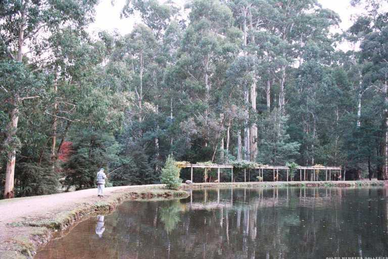
SubscriberYour assumption is correct digger but we really need the town where this pic was taken.
I was amazed at how this town has replicated many of the historic buildings.
Roger
ForumSage
SubscriberFriend here says Maryville trout or maybe salmon farm??
( not sure if he is taking the piddle or not!)
(REMLR 235/MVCA 9) 80" -'49.(RUST), -'50 & '52. (53-parts) 88" -57 s1, -'63 -s2a -GS x 2-"Horrie"-112-769, "Vet"-112-429(-Vietnam-PRE 1ATF '65) ('66, s2a-as UN CIVPOL), Hans '73- s3 109" '56 s1 x2 77- s3 van (gone)& '12- 110
AT REST
SubscriberI'm not sure if it was ever part of a trout or salmon farm but you are correct with the location of Marysville so it's congratulations & over to you digger.
Edit - 20160522
I just googled the Marysville Trout and Salmon Farm and that's a little out of town on Wicks Ck.
The subject pond in the picture is right in the middle of Marysville beside the Stevenson River. There was a guy catching trout in it when the photo was taken.
Anyway, digger, you got the town correct and that is all that was required.
Last edited by Xtreme; 22nd May 2016 at 01:18 PM. Reason: Checked on Trout Farm
Roger
 Posting Permissions
| Search AULRO.com ONLY! |
Search All the Web! |
|---|
|
|
|
 . Saw the photo on my phone and couldn't get a close enough look at it. Looks similar doesn't it?
 ")


Bookmarks